Once again, I’m sharing some of my medieval research with you for The Hunter & the Heiress. Last week, we talked about the Siege of Caerlaverock and insignia of medieval knights. This week, we’ll cross the Solway Firth to look at the history that inspired the fiction of Elizabeth’s home, the fictional Beaupoint.
One of the most remarkable resources surviving from 14th century England is called Gough’s Map. This map was completed around 1390 and is one of the earliest attempts to document the reality of the land, for navigation and travel. Previously, mapmakers were more interested in showing the relationship between territories and Jerusalem, or the evidence of the divine in the material world. (Check out my previous post Seven Medieval Maps. Gough’s Map is there, too.) Naturally, it has more detail further south and gets a big vague in Scotland, but it’s still a very useful resource. Here’s an image of the whole map from the Bodleian Library’s website:

You’ll notice right away that the orientation isn’t what you might expect. North is to the left, and south to the right. The map is drawn upon two pieces of vellum, which are seamed in Scotland.
The map is owned and maintained by the Bodleian Library (you can see in the image above that it’s stretched out) but they’ve made a digital (and searchable) version available of the map online right here. What’s really cool about this map is that you can search by modern location name, and in the little box at the top right, you can select details to be highlighted. If you choose Settlements, for example, a number of yellow dots appear on the map. When you hover over one, a question mark appears – click it and you’ll get the information from the map about that location. This tells us what settlements were established in the 14th century, which is pretty cool.
If you start at that seam and look to the right, you’ll see an estuary that indents toward 2 o’clock. That’s the Firth of Clyde. Carry on to the right and opposite an island (just past the notch in the bottom edge of the map) is an estuary that goes straight up and forks like a tree. This is the Solway Firth. That big island is the Isle of Mann. I took a detail shot of this area, since it’s where we want to be.
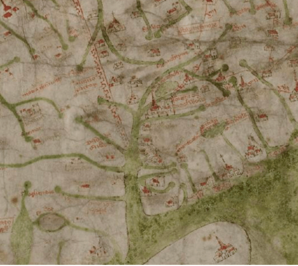
This is Solway Firth. You can see Hadrian’s Wall extending (east) toward 11 o’clock. Two rivers down from that, there’s a small red dot on the peninsula. This is Caerlaverock. Dumfries is the rectangle to the left of it. The church on the opposite side of the firth and slightly west (down) is Workington; at its 1 o’clock is Cockermouth. The big red church above them is Carlisle, and between Workington and Carlisle, there are four settlements marked: west to east (bottom to top) they are Holme Abbey, Kirkbride, Bowness and Burgh-by-Sands. Hermitage, the inspiration for Kilderrick, is also marked on the map – if you start up Hadrian’s wall, there’s a dark stain to the left between the sources of two rivers. The red mark for Hermitage is there. Just FYI, the two marks on the first peninsula on the left/north of the wall are unlabelled on the map. The right one must be Annan, the mote-and-bailey ca. 1160 which was abandoned by this time – because the route of the river changed – and the left one could be Lochmaben Castle, rebuilt by Edward I around 1300.
Hadrian’s Wall was in ruins in many sections by this time, not just having eroded by time and weather, but because stones were taken from it and reused. We know that the wall originally extended along the south side of Solway Firth, via Carlisle, continuing to Bowness, but the Gough Map shows it ending at the firth. This appears to be speculation about Scotland. 🙂
Here’s a screenshot of that section of Hadrian’s Wall, from the interactive map on the National Trails website, on the pages about the Hadrian’s Wall Trail. The trail is turquoise. (You can find that page, with a lot of great information about hiking the trail, right here.)

We can see the wall passing north of the original center of Carlisle, then continuing to Beaumont, Burgh-by-Sands, Drumburgh and finally Bowness on Solway. Across the firth is Annan. The marshes to the north and west of Burgh-by-Sands are shown here, as well—while rivers and their silt deposits change over time, the name of Burgh-by-Sands indicates that there was always a gathering of silt there. The marshes were there in the 14th century, too, because Edward I drowned in the Burgh Marshes in 1307 on his way to fight Robert the Bruce in Scotland. He laid in state in the church at Burgh-by-Sands and his momument is there. (It’s also marked on this map.) The town name also tells us that the church was fortified. There are some pictures of St. Michaels Church in Burgh-by-Sands on the Cumbria tourist site, right here.
But Beaumont is on this map, too, and this is one of our destinations today. On the Gough map, Beaumont would be between Carlisle and the first dot below it, Burgh-by-Sands. It’s not marked as a settlement, probably because it wasn’t one anymore by the 14th century. There had been a Norman motte-and-bailey keep built over a milestone lookout on Hadrian’s Wall, but in the 12th century, St. Mary’s church was built on the site instead. There are pictures of the church on that same Cumbria tourist site, right here, and you can see that it’s on a rise, which offers a view over the firth. The name itself means “beautiful hill” and the Hadrian’s Wall site makes note of the view to both the north and south.
Why was Beaumont changed from a keep to a church? I suspect the holding was simply too small to justify a keep of its own, particularly if the lord had larger holdings. Beaumont was historically held by the Brun family, who were lords of Bowness and also the patrons of St. Mary’s church. I found some geneology records which referred to a Richard le Brun (ca. 1300) holding Drumburgh, Bothel, Beaumont and Bowness. He was made a knight of the shire of Cumberland in 1307 and granted a license to crenulate Drumburgh in 1307. (Here’s an article about the pele tower in Drumburgh dating from 1307, which survives.) That would have been his main holding, then, if he wanted to fortify the structure. Throughout the 13th century, there are scattered earlier records of the family, listed as lord of Bothyl, bailiff of Egremont and steward of Coupland – another was sheriff of Carlisle. This was a powerful and affluent family, although in the fourteenth century, some of their holdings passed to the Dacre family. Drumburgh Castle was rebuilt (after disintegrating into partial ruin) before 1518 by Thomas Dacre.
The importance of Drumburgh lay in its location, near a popular ford over Solway Firth. These fords were called “waths” and were accessible at low tide. There were probably many waths, but this blogger has posted a map showing four: the Sulwath across the river Esk, the Peatwath across the river Eden, the Sandywath from Drumburgh to Dornock, and the Bownesswath, crossing firth from Bowness to Seafield. The waths were a way to get from England to Scotland without detection on the roads. (This explains why King Edward was in the marshes in the first place and why the Romans had so many lookouts on the south coast of the firth.)
Elizabeth’s fictional family holding in The Hunter & the Heiress is called Beaupoint and it was inspired both by Beaumont and Drumburgh. (So was her surname D’Acron.) Beaupoint is the site of a fictional and popular wath, defended on both sides – and her value as heiress of Beaupoint lies in the strategic importance of her family holding, as well as the wealth of her father’s treasury. It’s a keep rich in history, with Roman ruins underfoot. Her family has ties to the English crown, but also has historically switched sides for advantage. You can readily imagine how a woman raised in such privilege might not only insist upon having her own choice, but would be shocked by her situation when everything goes awry.
Nothing could be further from Amaury de Vries’ expectations than being compelled to join a company of mercenaries in the wilds of Scotland, much less one led by his notorious half-brother. He chafes to return to his former life of privilege and knows a wealthy bride will allow him to regain his stolen legacy. Elizabeth is a prize unexpected—beautiful and an heiress—and when she is abducted by barbarians, Amaury’s path is clear. He may not be the sole contender for the lady’s hand, but he knows himself to be the best one—and he will use whatever means necessary to seal his triumphant claim.
All Elizabeth D’Acron desires is to wed for love, but her inheritance has made her both a pawn and a prize. Caught between warring chieftains, her defiance blossoms—she chooses instead to flee with Amaury and make a marriage of convenience, hoping her trust in the gallant knight is not misplaced. She does not expect the beguiling fire awakened by Amaury’s touch, much less his unexpected conquest of her heart, and she dares to hope that true love has found a way.
But Elizabeth’s legacy is not so readily claimed—when Amaury’s plan is revealed, she is shattered to learn that her chivalrous husband is no different from other men. Recognizing that the true prize is his lady wife, Amaury rejoins the company of mercenaries and leads the battl to ensure Elizabeth’s freedom, whatever the cost to himself. Can these two lovers overcome the wounds of the past to build a future together? Or will the secret behind Elizabeth’s inheritance destroy any such hope forever?
Coming in January 2022!
The Hunter & the Heiress will ba availble in wide distribution for one week after publication, then it will be exclusive to Amazon and enrolled in Kindle Unlimited.
Pre-order available at some portals:
The Hunter & the Heiress will also be available in an audio edition, narrated by Tim Campbell.
